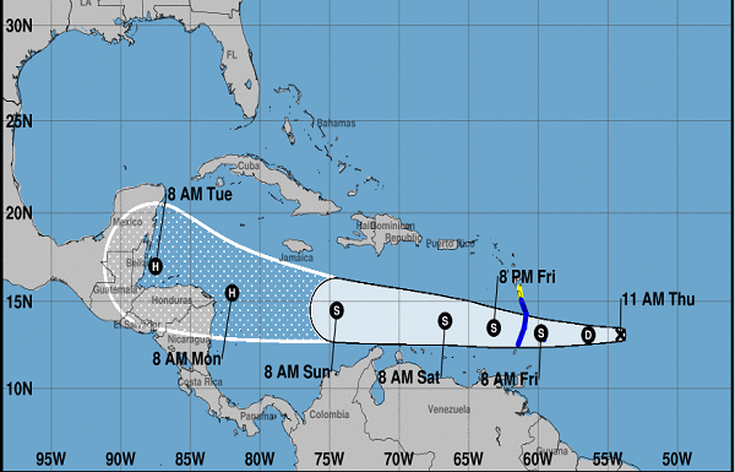
 A potential tropical storm watch has been issued for Dominica. The Low pressure area has been located east of the Lesser Antilles and is expected to become a tropical cyclone by later today or tonight with the potential to become a tropical storm before reaching the windward islands.
According to a report from the Dominica Meteorological Service, at 11:00a.m, the disturbance was located about 470 miles east southeast of Dominica. It is said to be moving toward the west near 17 mph (28 km/h) and this motion is expected to continue for the next couple of days. On the forecast track, the disturbance should move through the Windward Islands and into the eastern Caribbean Sea on Friday. Maximum sustained winds are near 35 mph (55 km/h) with higher gusts. A Tropical Storm Watch means that tropical storm conditions are possible within the watch area, in this case within 24-36 hours. Expected rainfall amount for Dominica is between 2 to 3 inches (50 to 75mm) with higher amounts in elevated areas. As a result, mariners and other users of the sea should remain extremely cautious and do not venture far from port. Meanwhile, persons in areas prone to flooding, landslides and falling rocks are advised to be extremely vigilant and to exercise caution as flash flooding and winds gusting to tropical storm force are possible tonight into Friday.
0 Comments
Your comment will be posted after it is approved.
Leave a Reply. |
Q95 NewsCurrent and past news stories. Archives
April 2024
Categories


|
 RSS Feed
ServicesAdvertising • Marketing • Promotions
News • Talk shows • Factual, Fair, Balanced Health • Advice • Events * Youth * Nutrition Kiddies program • Political views * Economy Information • Education • Entertainment |
|
|
|
Copyright.© 2000. All rights reserved. • WICE / Q95FM Radio, 10 Hanover Street, Roseau, Dominica • 1.767.448.5822 • 305.906.4216 • 347.430.4261
Designed and developed by Nicholes Designs